
CSUN Faculty Published in Comprehensive Historical Atlas of Los Angeles
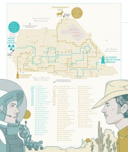
An illustration by David Deis for Steve Graves’ chapter in LAtitudes.
Los Angeles’ history is as rich as it is diverse. Two California State University, Northridge professors help tell the city’s story in a new anthology, “LAtitudes: An Angeleno’s Atlas,” on the historical geography of the Los Angeles area.
Geography professor Steve Graves, and history professor Josh Sides, are two of 19 contributing writers in the anthology, each telling a different story about Los Angeles’ unique, multifaceted history.
CSUN has a long-standing reputation for high-quality, cutting-edge cartography. It also boasts one of the largest map libraries in the western United States, located in Sierra Hall and open to students as well as the general the public.
“If anyone is going to make an atlas of Los Angeles, it’s us,” Graves said. “I’m not sure there’s anyone else who can do it.”
In the book, Graves authored the chapter “Woody and Buzz,” an interpretation of the landscape of the San Fernando Valley. The analysis uses “Toy Story” characters Woody, a cowboy, and Buzz Lightyear, a space explorer, to represent the contrasting western and space-age themes lingering from the post-World War II era. The Valley played a major part in developing space exploration technology, amid the contrasting “cowboy” terrain of ranches, horses, wagons, saddles and saloons in the North and West Valley.
“When I first moved here it struck me, “it’s Woody and Buzz,”’ Graves said. “Rocket Bowl, Wagon Wheel Car Wash, Rocket Fizz, Rocket Liquor. There’s lots of rocket stuff and cowboy stuff. So much of this was built in the 1950s… [space] seemed to be a significant fascination for Americans, so it’s a look into our cultural history.”
Sides co-authored the essay “Emperors of Dust,” a history of the earliest American settlers homesteading in Los Angeles County — small farmers carving out properties in the still un-manicured west.
Members of the Department of Geography were also heavily involved in producing the cartography and visuals for the anthology, published by Heyday Books.
David Deis, lecturer and staff cartographer for the department, was the chief cartographer for the book, designing unique maps specific to each chapter’s story. Professor Ron Davidson led a research team that provided geographical background information and proposed concepts for the maps.
“[Heyday] found in us what they were looking for,” Deis said. “A small number of people who were dedicated and really knew L.A. and had resources and connections of our own.”
The book has been well received. The Los Angeles Times said it “belies the laziest stereotypes of Los Angeles as a homogenous, undifferentiated mass,” and makes clear that “the city is both palimpsest and jigsaw puzzle, all layers and fragments.”
Los Angeles Magazine said “LAtitudes” “expresses the soul and spirit of Los Angeles.”
Graves said it is important to tell the many stories of Los Angeles, and that a geographical approach is a unique storytelling device.
“Maps are like words, they are a form of communication,” Graves said. “If a picture is worth a thousand words, then a map is worth at least a million.”