
CSUN Geography Students Take to the Sky to Better Study the Ground
-
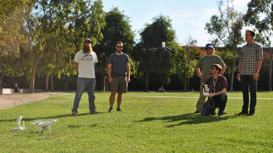
Geography Club members and majors (from left to right) Dannon Dirgo, Tyler Hehr, Inspire, Sean Robison, Nicholas Hager (holding the remote), and Ryan McGrath testing out one of the drones. Photo by Meliss Arteaga.
-
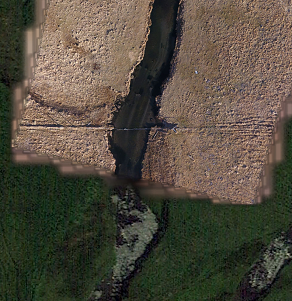
This is a picture comparing a UAV created high-resolution image (brown) and a Google Earth image (green). The UAV image is of higher quality with each pixel representing 1.5 centimeters on the ground. Photo by Sean Robison.
-
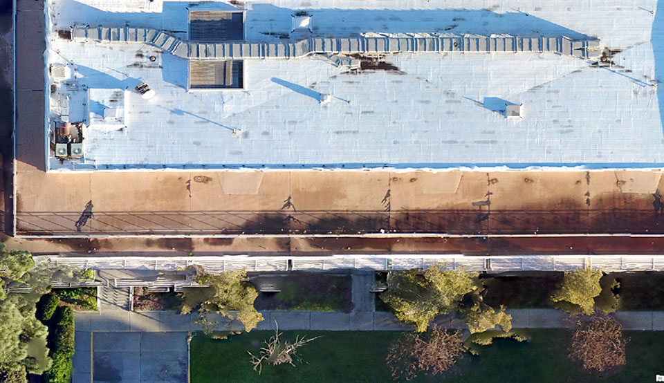
This is a high-resolution UAV created image of Sierra Hall. The Institute for Sustainability wishes to create a high-resolution image of the entire campus that can be used to create 3-D animation models of the campus for virtual tours. Photo by Sean Robison.
-
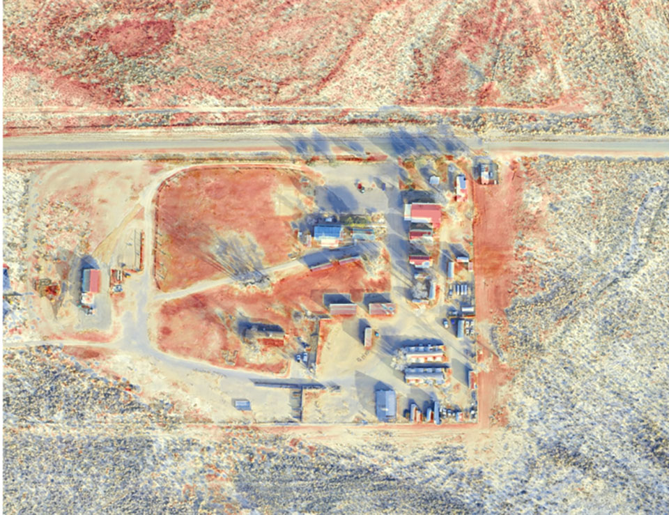
The heat island study at White Mountain Research Center aims to identify which land cover types retain heat in order to plant trees and ground cover in a way to reduce heat buildup. The Institute for Sustainability plans to conduct heat island studies at CSUN to create a cooler campus. Photo by Sean Robison.
The concept of unmanned vehicles and unmanned aircraft systems (UAS), known today as drones, was born out of the 1898 invention of the wireless-controlled boat by Nikola Tesla. Tesla’s invention helped pave the way for drone technology, which over the years has evolved in military use and beyond the battlefield.
The U.S. military has employed drones to carry out bombings, target practice and surveillance. Now, the use of drones has expanded to a multitude of different areas such as law enforcement, search and rescue, mining, real estate, construction, media, wildlife conservation, agriculture and applied sciences.
The Department of Geography at California State University, Northridge, one of the largest such programs in the nation, is collaborating with CSUN’s Institute for Sustainability this year to implement a new drone program. CSUN officials expect the new drone program to help develop strategies to make the campus more sustainable — and arm students with the skills and knowledge needed for future careers in fields that use drone technology.
The department will launch a test course on drones during the fall semester of the 2017-18 academic year. The university will introduce the class for geography and environmental studies majors, according to geography professor Amalie Orme, who joined the Institute for Sustainability as a faculty associate for research. Students in the class will study field skills such as building and deploying a weather station, how to use drone images when monitoring the setup for weather stations and monitoring landscape change.
Orme first introduced drones in the geography department during the 2015-16 school year, during California’s historic drought.
“We were trying to document the landscape under extreme conditions, where we were losing trees, other types of vegetation and water supply was low,” Orme said. “With the tremendous rainfall we had this year, we are now able to look at change as the ecosystems recover.”
In previous years, department faculty, graduate students and undergraduates had conducted extensive field mapping using sophisticated, traditional instruments such as weather stations, light detection and ranging (a remote-sensing method), and global positioning system (GPS) units linked to Google Earth. After reviewing the images, they realized they needed greater detail in order to gauge environmental changes.
Two CSUN geography students purchased drones for their own personal use and soon saw the incredible increase in detail and resolution they could achieve in the mapping images, Orme said.
One of the students, Sean Robison, a graduate student, was looking for ways to link the images with location points and elevation points on the ground. This would provide the department with images with rectification, points on the ground to which student and faculty researchers could return, Orme said. These points enable geographers to monitor environmental changes.
“Our goals really began to be very precise mapping to look at change in landscapes over time, and it seemed appropriate that we start a program that is based both in geography and in the Institute for Sustainability,” Orme said.
Robison, a licensed flight instructor with more than 1,000 hours of flight time, has worked closely with the other students, teaching drone safety and how to navigate through the complicated software programs.
“This UAV (unmanned aerial vehicles) type of science is being adopted by not just geography, but all disciplines,” Robison said. “There’s so much that can be done with it. Over the coming years, it’s going to be part of everyone’s life — like computers, it’s going to be ubiquitous. We’re excited that we are on the front edge of this movement.”
To generate more student interest in the program, the department enlisted the help of the CSUN Geography Council, a campus organization. The council president, Marcella Rose, has visited CSUN classrooms and other campuses around the area to demonstrate how the geography department and Institute for Sustainability have used drones for environmental mapping. The budding geographers plan to form a CSUN student group called the Aerial Environmental Research Group, Orme said.
This new drone program could cost the geography department several thousand dollars. However, the exact amount is tentative, she said. The actual cost of the program will depend on the number of drones purchased, replacement equipment and repairs, and the number of computers and software programs required to set up in the lab.
“It’s a lot of money, there’s this whole support system people don’t see,” Orme said. “We’re trying to tackle this one computer at a time, investing a little bit at a time.”
There are multiple sources of funding from the geography department and the Institute for Sustainability: The department receives funding from CSUN’s Instructionally Related Activities (IRA) and the College of Social and Behavioral Sciences. The Institute for Sustainability receives funding from the Office of the President as well as from CSUN Facilities Planning Services.
Geography and sustainability students are currently using three drones on campus: an Inspire drone with a thermal camera attached, a Phantom 4 with an RGB (red, green and blue color component) camera and a Phantom 4 with NDVI (normalized difference vegetation index) or infrared/heat sensor. These types of drones can map environmental landscapes in 2-D and 3-D with an accuracy of two centimeters.
The flying of drones on campus is governed by strict regulations and policies established by CSUN administration: permission from the Federal Aviation Administration and the university, a licensed pilot for the larger Inspire drone, training, filing of flight plans and flying at times when there are very few people on campus.
The Institute for Sustainability is using the Inspire drone to collect data on heat loss from campus buildings and to assess the impact of exposed grass areas and moisture retention in the soil. With these projects, administrators and faculty aim to identify areas of campus where there are “hot spots” or “cold spots” — zones where temperatures are above or below what the department believes they should be at — and develop mitigation measures to develop a thermally sustainable campus.
Robison said achieving a sustainable campus will require an efficiency evaluation of current energy and water use, and utilizing drones equipped with high-resolution sensors offer safe and innovative approaches to assessing CSUN’s resource usage.
“We are very excited to implement this program,” said Orme. “This is not a stand-alone project. We have integrated the drones into a 21st century mapping program that uses high-level GPS, the establishment of ground truthing (information obtained by direct measurement at ground level used to verify or calibrate remotely obtained data) for accuracy and the generation of 3-D models of landscape change.”
The geography department and Institute for Sustainability officials plan to add more projects around campus that use drone technology in areas such as sustainable plant growth, reducing the heat-island effect, reducing water use and capturing storm water.
“In the coming years, if all goes to plan, we’re going to be able to offer students a pathway to learning how to use this equipment, how to get their certification and how to develop these job skills, so that when they leave CSUN [they’ll] be well trained and ready to compete with other schools,” Robison said.
Drone technology represents the future of mapping in geography, Orme added.
“We’ll still do traditional ground mapping, but this way, students create their own data — they’re not working off of someone else’s database,” she said. “They ask the question, figure out how to answer it, collect the proper data and then own that data. They can do something original, creative with it. This is do-it-yourself from the ground up. It’s critical that our students have a multitude of skills. You can’t get a good job with just one skill.”
For more information on the Institute for Sustainability, go to www.csun.edu/sustainability